The No. 1 trail starts in Prima Cappella, which can be easily found by heading north out of the city centre through Sant’Ambrogio Olona and following the road upwards until you reach a large car park in Piazzale Montanari. From Piazzale Montanari follow Via Guido da Velate uphill until the junction between Via Prima Cappella and Via del Santuario, where we find the first signpost for the trail. This arch also marks the starting point for the “Via Sacra”, a cobbled road that wends its way up the southern slope of Sacro Monte for about 1.3 miles, taking you past fourteen seventeenth-century chapels on the way up to the ancient village of Santa Maria del Monte. Each chapel is dedicated to one of the Mysteries of the Rosary, which are illustrated with frescos and sculptures.
From the top of Viale delle Cappelle the No. 1 trail follows Via del Ceppo until you reach the large Piazzale Pogliaghi, an excellent viewing point for admiring the Rasa Valley, Monte Martica and the alpine foothills in Lombardy. This is also a great point to join the No. 1 trail as it has stops for public transport and a large car park.
After twenty or thirty yards on Via Monte Tre Croci, take the trail on the right towards Pizzelle at the north end of Piazzale Pogliaghi. This trail winds its way up the hill towards the Pizzelle pass and is often quite uneven as heavy rain sometimes washes away the surface. Along the way you will notice several natural water management and engineering projects carried out by the Campo dei Fiori Regional Park, in cooperation with other organisations, to repair the trail and the mountain side following a series of landslides that occurred in recent years.
While following the trail you will also see the typical rough pastureland on the right towards the mountain; this pastureland has lime soil and provides an excellent habitat for a fascinating range of flora and fauna.
Next you come to the Pizzelle pass (926 m - 3038 ft), where we find the turn-offs for the No. 3 trail (to Fontana Rossa and Castello Cabiaglio) and the No. 4 trail (to Valle Intrino and Brinzio).
After that you are in the Campo dei Fiori Regional Park.
THE NO. 8 TRAIL JUNCTION
The trail continues to climb up to some coppiced woods until it meets the junction with the No. 8 trail (Santa Maria del Monte-Pizzelle and back) on the left.
FUNICULAR RAILWAY STATION
After a couple of hundred yards you reach the former funicular railway station. Together with the former Panoramico restaurant, the station is part of a group of Art Nouveau buildings that made up the Campo dei Fiori Grand Hotel complex.
In the park opposite the Grand Hotel we find the Marelli Grotto, a karstic cave that is one of the most significant of the many found on Mount Campo dei Fiori.
After a fifteen-minute walk along the mule track past the right of the former station we get to the overhanging limestone rock faces of the practice wall, where the Varese branch of the Club Alpino Italiano (the Italian Alpine Club) comes to do challenging mountain climbing exercises.
After climbing the steps up into the fir-wood above the Grand Hotel, you get to a square below a small church. Just above this is Monte Tre Croci, which can be reached by following the lane with memorials commemorating members of Italy’s armed forces who have lost their lives. The three huge crosses on the top of the hill are a symbolic reproduction of Mount Calvary and were first erected in 1636. The central monumental cross was created by the sculptor Lodovico Pogliaghi and erected in 1900 to mark the Jubilee.
The trail continues past the three crosses towards the top of the mountain until you get to a turn-off taking you to the viewing point in the large “Piazzale della Batteria”, which was once used by the army and part of the Cadorna Line; it offers breathtaking panoramic views across the mountains and valleys that make up the alpine foothills, and over the Central Alps. The Varese branch of the National Artillery Association installed a cannon here in 1987.
Continue along the tarmacked road (Via Al Forte), keeping Bar-Ristorante Irma, a characteristic bar and restaurant and the only eatery on the mountaintop in the Campo dei Fiori Regional Park, to your left. This place is a great spot in which to join the No. 1 trail as it has a large car park and is only a couple of hundred yards up from the bus terminus (next to the barrier across the access road to the Grand Hotel) for the A.V.T. buses that arrive from Sacro Monte.
You will find the start of the No. 7 trail at the end of Via Al Forte, just before the chain that prevents unauthorised traffic from entering the road to Piazzale Belvedere and the gate to the “Cittadella di Scienze della Natura” (the citadel of natural sciences) on the right. The No. 7 trail offers breathtaking panoramic views (particularly in winter when there are no leaves on the trees) and leads across the steep northern slope of Cima Paradiso to Punta di Mezzo and then on to the Orino Fort via the strada militare (army road).
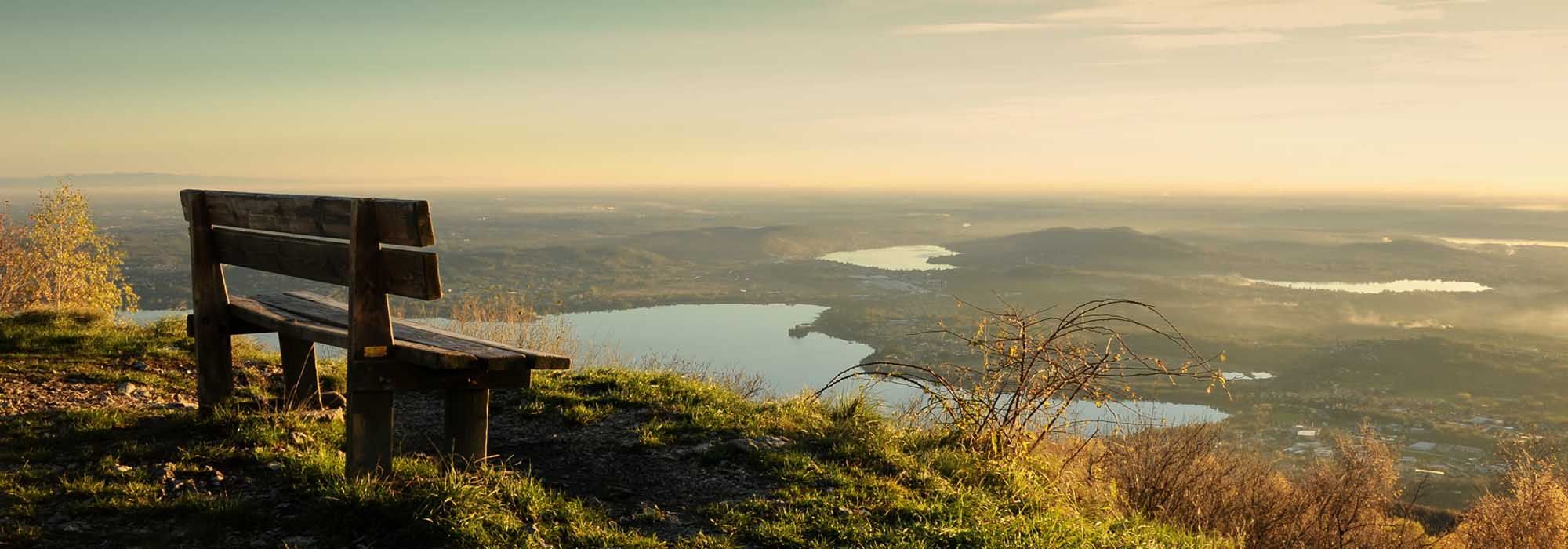
A hundred yards or so past the chain across the road is “Piazzale Belvedere”. This is an astounding viewing point with benches and a panoramic view over the Varese hinterland and Po Valley. It is also the start of the Wellness trail set up by the Varese Tourist Board that was renovated by the Campo dei Fiori Regional Park in 1998.
On Piazzale Belvedere you will also fine the entry gate to the “Cittadella di Scienze della Natura” (the citadel of natural sciences), where the G.V. Schiaparelli astronomical observatory is located on the top of Cima Paradiso.
The unsurfaced track known as the strada militare (army road) to Orino Fort starts just past Piazzale Belvedere.
The army road to Orino Fort climbs beneath the various peaks in the Campo dei Fiori Regional Park, wending its way through stretches of coppiced woodland, fir-woods and larch woods and joins up with the various turn-offs listed below:
The final stretch of the strada militare (army road) has several twists and turns before reaching the peak known as the Orino Fort. This military fort was once part of the Cadorna Line, built in the First World War, and now offers breathtaking panoramic views over the alpine foothills, the Piedmontese and Central Alps and Lake Maggiore as well as the western part of the Po Valley and the Varese lakes.
*The itinerary is also suitable for mountain biking.
DETAILS:
- Duration: 4 hours
- Distance: 9 km
- Difficulty: easy
- Altitude: 539 mt.
- Starting point: location Prima Cappella
- Arrival point: Orino fort
- Parking: Piazzale Giuseppe Montanari
Complete your journey: reach your destination thanks to Trenitalia